Unlocking the mundane mysteries of the world
Last edited Mon Jan 12, 2026, 01:19 AM - Edit history (1)
How Bellingcat is training people to take a critical eye to photos and videos, finding information buried beneath the surface.
This week's newsletter:
www.howtoreadthisch.art/unlocking-th...
— Philip Bump (@pbump.com) 2026-01-10T15:10:43.890Z
How to Read This Chart
Unlocking the mundane mysteries of the world
Philip Bump
10 Jan 2026 — 12 min read
 Various images from
 the National Archives combined to make something vaguely movie-poster-like.
Congratulations; Hell Week is over. In preparation for Hell Week Redux, whenever it may arrive (next week), this week's newsletter flips data visualization on its head, focusing on a fascinating project that extracts data from presentations that wouldn't seem to include any.
Also, President Trump shared a chart that we should talk about. As I said: Hell Week.
Chapter 1
Inverted data visualization
When I first saw it in 2015, the photograph below
reshaped my approach to journalism.
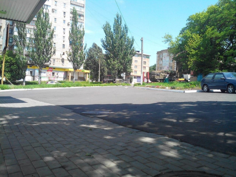
Torez, Ukraine, July 17, 2014. (Bellingcat)
You will be forgiven if
it is not immediately apparent why. At a glance, it looks like a not-particularly-interesting scene from a city, maybe one — if one were to engage in
a little Geoguessrism — somewhere in Europe.
But there's a detail that, a decade ago, made this photo particularly important: That brownish-green vehicle that's about to pass behind the tree at the righthand edge of the picture. That is a
Russian Buk missile launcher, a system that, a few hours later, would fire the projectile that downed Malaysia Airlines Flight 17, killing nearly 300 people.
Russia fervently denied (and still denies) involvement. So knowing where this missile launcher was and when became an important part of the investigation. But, with no metadata attached to the picture — digital information appended to photos or videos that can include time, location and camera data —
how could investigators prove that the Buk was in the right place at the right time?
Enter Bellingcat. Founded by Eliot Higgins, Bellingcat is an independent collective of open-source investigators, people who work together to review publicly available information — like the photo above, which was posted to social media — and fit them into complex puzzles.
In the case of the photo, finding the physical location was perhaps the easy part. It was in a town called Torez, in the contested Donetsk region of Ukraine. But the amateur investigators were also able to determine the time of day by
looking at the shadows. The sun was almost overhead, just as it was at about 12:30 on the day of the attack.
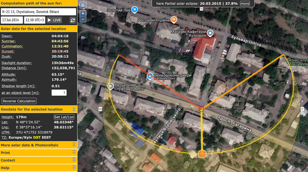
Calculating historic sun positioning using the online tool SunCalc.
This determination put the Buk on a path that made it the likely culprit in the MH17 disaster. {snip} Meanwhile, Bellingcat's real-world work continues. This week, that meant
analyzing video from the killing of Renee Good in Minneapolis.
{snip}
Bellingcat
@bellingcat.com
Using imagery online of the shooting by an ICE agent in Minneapolis, we’ve created an animated sequence which highlights the approximate positioning of officers and vehicles at the scene. The red dot represents the agent who fired the shots. Yellow dots are other agents who arrived at the scene.
5:33 PM · Jan 7, 2026
Using imagery online of the shooting by an ICE agent in Minneapolis, we’ve created an animated sequence which highlights the approximate positioning of officers and vehicles at the scene. The red dot represents the agent who fired the shots. Yellow dots are other agents who arrived at the scene.
— Bellingcat (@bellingcat.com) 2026-01-07T22:32:56.273Z
?ref=howtoreadthisch.art
 = new reply since forum marked as read